Lesson 4 — Mapping and Alternate Routes
The test below stays in English. You must pass the test in English.
Lesson 4 — Mapping and Alternate Routes
The route you didn't verify is the route the driver crashes on.
Why this matters
The driver follows your route. If you pick a bad route, the driver pays the price.
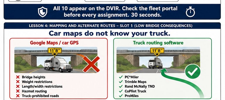
The thesis applied to routing: the route you did not verify is the route the driver crashes on. Google Maps is for cars. Cars do not have 13'6" of height, 53 feet of length, 80,000 lbs of weight, or restrictions from parkways and residential streets. A truck routed by a car map is a truck routed into a low bridge, a weight-restricted road, or a residential turn it cannot make.
VTTI research explicitly names "use of a laptop or dispatching device to perform complex tasks" as a major distraction category. Their data shows texting and device-based routing while driving raises CMV crash risk by a factor of 23. A driver who has to re-route on their phone because dispatch did not pre-plan an alternate is, by VTTI's own measure, in one of the highest-risk situations on the road.
Car maps vs. truck routing — the difference is the lesson
Car maps know: where roads exist, where they go, current traffic.
Truck routing programs know: all of the above, PLUS:
- Bridge heights. Avoids low bridges. Google Maps does not.
- Weight restrictions. Avoids roads/bridges over the truck's weight. Google Maps does not.
- Length and width restrictions. Avoids tight turns, narrow streets, parkways.
- Hazmat routing. Avoids tunnels and routes that ban placarded loads.
- Truck-legal vs. truck-prohibited roads. Knows which roads are residential or signed "no trucks."
Connect: PC*Miler, Trimble Maps, Rand McNally TND, CoPilot Truck, ProMiles — these are the tools. Cost is $10-$50 per driver per month. A single low-bridge strike costs $20,000-$200,000.
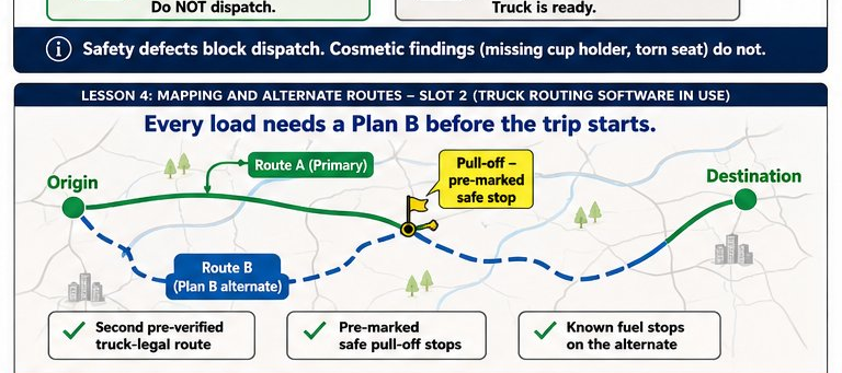
Image 1 — Low bridge consequences
Plan B — every load needs one
Primary routes get closed. Accidents shut interstates for 4-8 hours regularly. Weather closes mountain passes. Construction reroutes thousands of trucks an hour.
If you dispatch a load with one route and no alternate, you are choosing to let the driver figure out a re-route mid-trip — by phone, while moving. That is the documented VTTI 23x crash-risk scenario.
Plan B looks like:
- A second pre-verified truck-legal route between origin and destination
- Marked stops where the driver can pull off safely and switch routes
- Known fuel stops on the alternate (so a switch does not strand the driver)
The dispatch device distraction
VTTI's finding is specific: complex device tasks (looking up addresses, re-routing in apps, reading dispatch messages) while driving raise CMV crash risk by a measured 23x. Texting alone raises it 23x. Combine the two — texting AND re-routing — and risk multiplies.
A driver who has to figure out the route from scratch because dispatch sent only an address and a pickup time is being put into the highest documented risk category on the road. The dispatcher caused it.
What you do as a dispatcher
- Use truck-specific routing software for every load. Not Google Maps. Not your phone. PC*Miler, Trimble Maps, or equivalent.
- Verify the route before assigning. Look for low bridges, weight restrictions, hazmat exclusions, residential dead-ends.
- Verify the route is truck-legal before assigning. Driver may have their own preferred route, and that's fine — the dispatcher's job is to confirm any reasonable route between origin and destination is truck-legal. For hazmat, oversized, or company-restricted freight, send the required route explicitly.
- Identify a Plan B corridor. Know an alternate truck-legal corridor in case the primary closes. The driver may already know one — confirm in advance, don't leave it to mid-trip phone re-routing.
- Update if conditions change. Weather, closures, incidents — push the new info to the driver BEFORE they need it.
The thesis, restated
The route you did not verify is the route the driver crashes on. The driver crashes — or strikes a low bridge, or violates a residential weight limit, or texts to re-route at 23x risk. The dispatcher made the routing decision. The driver carries the consequence.
Next step
Take the short quiz below. 5 questions in English. You need 4 of 5 correct to pass.
Image 2 — Truck routing software in use
📋 Sample Quiz Questions (Preview)
These are the questions on the quiz at the end of this lesson. The actual quiz is taken after logging in. Correct answer marked with ✓.
- ○ Google Maps is fine for trucks under 60 feet
- ✓ Google Maps routes for CARS — it can send the truck under a low bridge, onto a parkway that bans trucks, or down a residential street it cannot navigate
- ○ The driver will recognize bad routes and adapt
- ○ Truck routing and car routing are the same
- ○ 2x
- ○ 5x
- ✓ 23x
- ○ It does not raise crash risk for experienced drivers
- ○ Drivers should always know alternate routes themselves
- ✓ The dispatcher's job is to verify routing. Sending a single route with no Plan B puts the driver into the VTTI 23x distraction risk when the primary fails — which is foreseeable
- ○ Accidents are unforeseeable
- ○ Re-routing on the shoulder is the safest option
- ○ Avoids low bridges
- ○ Respects weight restrictions
- ○ Routes to truck-legal roads (no parkways, residential bans)
- ✓ Automatically reduces the driver's HOS time
- ○ Just the destination address — the driver will figure it out
- ✓ Pre-loaded turn-by-turn route in the ELD/in-cab device, plus a Plan B route with trigger conditions — sent BEFORE the trip starts
- ○ Phone call with verbal directions during the drive
- ○ Text message at each major decision point
End of preview. The actual quiz requires login to record a grade.